- (218) 634-1842 ext 4
- staff@lakeofthewoodsswcd.org
- Mon - Fri: 8:00 - 4:30
PROJECT:
LAKE OF THE WOODS WATERSHED RESTORATION AND PROTECTION PROJECT (WRAP)
RECENT UPDATES
This project was concluded June 2016.
KEY CONTACTS
Email tmdl@lakeofthewoodsswcd.org with your general questions.
You may also contact one of the project managers listed below.
- Cary Hernandez, MPCA Project Manager, cary.hernandez@state.mn.us, 218-846-8124
- Mike Hirst, Lake of the Woods SWCD,
mike.hirst@mn.nacdnet.net, 218-634-1842 x4 - Julie Blackburn, RESPEC Project Manager, julie.blackburn@respec.com, 651-605-5705
ABOUT THE WRAP
The SWCD is assisting with a project to assess the health of the Lake of the Woods Watershed. This project is called the Lake of the Woods Watershed Restoration and Protection project (WRAP).
The Lake of the Woods WRAP is being conducted to address those waters that are known to be impaired and also to assess the state of other waters in the watershed. The goal of the Minnesota Pollution Control Agency’s (MPCA) watershed-wide design to addressing Total Maximum Daily Loads (TMDL) is to develop a comprehensive plan for managing surface water quality across the entire watershed, rather than focusing on a single waterbody at a time. To learn more about the MPCA’s watershed approach to TMDLs, click here.
The ultimate goal of the Lake of the Woods WRAP is to protect waters where conditions are excellent and restore waters that are impaired.
WHAT IS A WATERSHED RESTORATION AND PROTECTION PROJECT (WRAP)
The State of Minnesota has adopted a 10-year cycle for managing water quality for each of the 81 major watersheds in the state. Every 10 years, each major watershed will undergo a Watershed Restoration and Protection project (WRAP).
An WRAP consists of three phases:
Phase I – Determine the health of the water bodies in the watershed.
Phase II – Develop strategies to protect and/or restore the watershed’s water bodies
Phase III – Conduct restoration and protection projects in the watershed
It is the goal of the Minnesota Pollution Control Agency (MPCA) to complete each WRAP within a four-year period. The LOW Watershed is entering into its first 10-year cycle with the Phase I Intensive Watershed Monitoring (IWM) schedule to begin in 2012.
WHAT AREAS ARE COMPRISED IN THE LAKE OF THE WOODS WATERSHED STUDY?
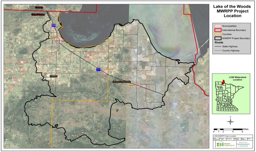
The Lake of the Woods (LOW) Watershed, located in north central Minnesota, comprises an area of 734,783 acres. The watershed is on the United States-Canada border, and is part of the Rainy River Basin. The subject area of this project is the LOW watershed’s land located on the south end of the Lake of the Woods. The LOW Watershed’s land on the north end of the lake (the Northwest Angle) is predominately undeveloped Red Lake Indian Reservation lands and is not included in the scope of this project.
WHO IS CONDUCTION THE PROJECT?
The Lake of the Woods SWCD is the local governmental unit leading the WRAP effort under contract with the MPCA. Houston Engineering, Inc. and RMB Environmental Laboratories, Inc. are supporting the SWCD in these efforts.
IS THE PUBLIC INVOLVED?
It’s important that those who live in the Lake of the Woods Watershed are part of this project. The project team includes a group of stakeholders that represents land owners and residents. Anyone who is interested can join this group at any time or attend any of the public meetings associated with the project. As the project reaches important milestones, such as completing the reports mentioned above, open houses are held to share results and discuss findings. Upon request, the project team will also share developments with local groups.
Focus group meetings will be held throughout the process. The intention of these meetings is to discuss on-going water quality monitoring efforts in the Lake of the Woods Watershed, and to introduce the concept of the MPCA’s Watershed Approach.
PUBLIC MEETINGS
NOVEMBER 1, 2012
Kick-off meeting for Warroad and Lake of the Woods Watershed Studies
OCTOBER 2, 2012
MARCH 9, 2012
Kick-off meeting in Baudette fro Phase 1 of WRAP
REPORTS
The full size report can be made available upon request to the SWCD.
GIS shapefiles are also available for the Terrain Analysis. Send request to the SWCD.


